OPEN DATA FOR A CONNECTED TRIP
Ireland mobile network map
Compare recorded mobile cells across Ireland networks. Explore a place, filter radio technologies and download the sourced data. This is not measured signal coverage.
All listed networks
Recorded cell density, not signal strength. The static overview shows all listed networks.
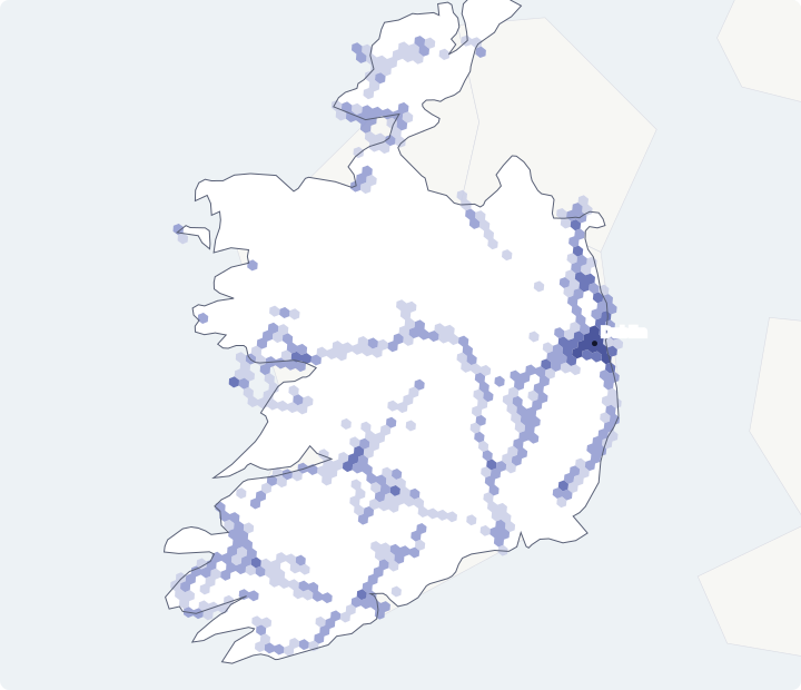
These are estimated positions of recorded cells. This is not a signal guarantee or speed test. No data does not mean no mobile service.
Cell tower data from OpenCellID, licensed under CC BY-SA 4.0. Changes: recorded cells filtered to at least 2 contributed measurements and grouped into H3 resolution 6 hexagons. Standard exports contain cells observed within the last 18 months.
Land outlines and listed places: Natural Earth, public domain.
Check a stop on your route
Choose a listed place or enter coordinates above, then select “Check recorded cells nearby”. The result counts recorded cells within 10 km, not signal strength.
THE RECORDED DATA
Ireland networks in this dataset
Compare what contributors recorded. A network's share of these records is not its share of land, population or signal coverage.
| Network | Recorded cells | Share of country records | 4G / LTE records | 3G / UMTS records | 2G / GSM records | Network identifiers | Source |
|---|---|---|---|---|---|---|---|
| Eir (272-03) | 2,838 | 51.8% | 2,573 | 248 | 17 | 272-3 | See the downloaded source |
| 3 (272-05) | 1,749 | 31.9% | 1,749 | 0 | 0 | 272-5 | See the downloaded source |
| Vodafone (272-01) | 662 | 12.1% | 629 | 5 | 28 | 272-1 | See the downloaded source |
| 3 (272-02) | 230 | 4.2% | 8 | 214 | 8 | 272-2 | See the downloaded source |
A recorded cell is a radio-network identifier with an estimated position. One physical site can serve several cells, sectors and radio technologies. Zero records in a column do not establish that a network lacks that technology.
READ THE MAP CORRECTLY
How this Ireland map was built
- Use the OpenCellID export for the listed mobile country codes. Standard exports contain cells observed in the last 18 months.
- Keep valid coordinates and cells with at least 2 contributed measurements. Several cells can belong to one physical site; these are cell counts, not a tower census.
- Group the retained records by serving-network identifier, radio technology and H3 resolution 6 hexagon. A resolution 6 hexagon averages about 36.13 square kilometres; its area varies by location.
- Show counts and dates from this snapshot. Its observed-date range is 2025-04-20 to 2026-10-16. A download date is not a new observation of every cell.
- For a place check, count estimated cell positions within a 10 km radius of your chosen point. Share your choices only by explicitly copying the link.
Country selection uses configured geographic bounds and mobile country codes. The bounds are not a precise administrative-border filter. Contributions are uneven across operators and places. We do not derive land coverage, population reach, network reliability or signal-strength scores from these counts.
Network names and codes are cross-referenced against the community-maintained MCC-MNC list, with selected operator identities checked against official sources. The identifiers remain visible in the table. A listed name does not establish current commercial roaming access or frequency bands.
Read OpenCellID's explanation of cells, coordinates and missing records · H3 resolution and area reference
BEFORE YOU CHOOSE A NETWORK
Questions about mobile coverage in Ireland
Does this show actual Ireland signal coverage?
No. It shows estimated positions of qualifying cell records contributed to OpenCellID in Ireland. It does not measure indoor service, mobile speeds, congestion or a phone's reception. Terrain, buildings, the handset and plan conditions can change the connection.
How are the Ireland networks separated?
Records are grouped using the mobile country code and network code, together called MCC-MNC. Those codes identify the recorded serving network, not the retail eSIM brand or the owner of a physical mast. Unmapped identifiers must not be guessed. This snapshot contains 4,959 LTE records and 0 NR records across the listed network groups.
What does an empty area on the Ireland map mean?
It means this dataset has no qualifying records for the selected network and technology in that area. Contributors do not sample every location equally. An empty area is not evidence of no service; check the operator's own map and conditions.
Can I check Ireland 5G availability with this map?
This snapshot has no qualifying NR records. The map therefore does not offer a 5G / NR filter. This does not establish that 5G is unavailable; check current operator information and your exact eSIM terms.
Which network will my travel eSIM use in Ireland?
Check the exact package's current provider-published network list and roaming conditions before buying. OpenCellID cannot identify an eSIM brand's roaming permissions. The comparison link on this page does not promise access to a particular operator.
What does the nearby-place check count?
It counts qualifying recorded cell positions within 10 km of the point you selected, by network and radio technology. The distance is from an estimated cell position, not a measured signal boundary. A larger count is not a guarantee of better reception.